


Description
- Designed for Crop Mapping and Analysis
- Video Camera and Multispectral Sensor
- Capture 1080p Video and 14MP Photos
- Covers up to 65 Hectares per Charge
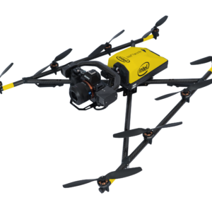
The Parrot Bluegrass Fields Quadcopter for Agriculture is a crop mapping and analysis tool that can quickly provide actionable data to farmers, retailers, insurers, and anyone else who works directly within the agriculture industry. The Bluegrass Fields obtains its information via two included sensors. There’s a 14MP visual sensor that’s capable of taking hi-res photos and capturing video at up to Full HD 1080p60 quality, and a multispectral sensor that reads red, green, red edge, and near infrared wavelengths emanating from the field.
The Bluegrass Fields drone is capable of flying high for coverage of up to 65 hectares at 400′ to get a bird’s-eye view of large fields such as wheat, barley, or corn. It can also fly as low as 32′ to give more precise pictures of crops such as strawberries, blueberries, or grapes. Three batteries are included for a maximum flight time of approximately 75 minutes. While out in the field, its carbon fiber construction helps to ensure it can withstand the elements.
When out in the field, you can utilize the ParrotFields mobile app to help you perform a variety of essential tasks, such as fully automating your flights or generating NDVI maps in real time. Once the data is collected, use the Pix4Dfields desktop and cloud software to analyze the results. The insights you gain can lead to revelations in crop trends, optimizations in fertilizer applications, and more. With Bluegrass Fields you get a free 1-year subscription to both applications.
ParrotFields Mobile App
Pix4Dfields Software
Pix4Dfields takes all the raw data obtained from each of the drone’s sensors and gives you the ability to analyze and process it to gain insights on your crops. The software engine is capable of processing approximately 50 hectares (123 acres) of data in just 1.5 minutes, letting you more easily visualize trends and generate maps for more targeted crop management. Here are some specific features you can enjoy with your free 1-year subscription:
- Generate predefined or custom index maps for detailed crop performance analysis
- Compare different data layers side by side to visualize crop trends
- Creative comprehensive zonation and prescription maps for more precise fertilizer applications
- Import or draw field boundaries and annotate crop ‘focus areas’ for more in-depth inspection in the future
- Export prescription maps to a tractor or Farm Management Information System for integration into an existing workflow
Reviews
There are no reviews yet.