How Drones Help Manage Water at Northern Water Conservation District
![]()
Due to loosened commercial drone regulations by the Federal Aviation Administration (FAA) in 2016, water utility companies are exploring how commercial drone use can help them manage maintenance or leaks on pipelines and map topography to help with planning for future lines.
Remote sensing cameras mounted on unmanned aerial vehicles (UAV) can now allow for rapid inspection of underground pipelines. Images are recorded in different spectral bands, from the visible to the short-wave infrared and in the thermal infrared band and are then interpreted by experts. Leaks can be detected through changes in the nearby environment surrounding the pipeline. For example, thermal infrared imaging can detect increased soil moisture through changes in ground temperature.
By combining both visual and thermographic inspection from commercial drone use, water companies can discover potentially hazardous problems before they become dangerous or financially demanding.
Commercial Drone Use – A Use Case Introduction
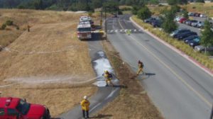
Recently, 1UP Aerial Drone Services had the opportunity to demonstrate the viability of commercial drone use for Northern Water Conservation District on a large metropolitan canal and feeder pipeline. In addition to contracting 1UPs professional UAV scanning and inspection services, the water organization also participated in training courses that will enable them to potentially adopt this technology in their own operations and maintenance. “This will give Northern Water much greater awareness of the large land masses that they serve and save countless hours searching for leaks, potential issues with canals, pipelines, adjacent property, and allow Northern Water to be proactive on detecting and performing new construction and repairs”, states Chuck Adams, CEO, 1UP Aerial Drone Services.
The entire operation proved beyond doubt that various aerial scanning technologies combined with commercial drone use can detect both existing and potential problems. In addition, the ability to position a UAV exactly by utilizing “geo-tagged” GPS technology can aid in inspecting and mapping land in the most remote locations for future water projects.
Commercial Drone Use – Training
The classes involved two sessions that gave Northern Water personnel a chance to simulate flying drones by utilizing drone piloting flight simulation software. This included basic familiarization with the piloting controls and unique handling characteristics of various types of payloads, weather changes, and UAVs used in commercial applications.

Additionally, training participants learned the appropriate FAA requirements and flight regulations that apply to commercial drone use, including:
- Drone registration
- Flight Planning Process
- Designated No-Fly Zones across the United States
- Localized No-Fly Zones
- sUAS Laws relating to Restricted Airspace
- Commercial Drone Use and Visual Line-of-Sight regulations
- Operating a UAV from a Moving Aircraft
- UAV Operators should maintain a minimum 50-meter distance from public bystanders and other project non-participants
- Mandated fines and penalties for commercial drone use violations
Commercial Drone Use – Camera Technology
Imaging technology for commercial drone use far exceeds the amateur hobbyist’s GoPro or iPhone attachment. Today’s UAV camera technology includes:
- 4K Ultra HD Video
- 1080HD slow motion
- 42MP still images
- Infrared, LiDAR, & Multi-spectral imaging
- 3 axis gimbals for stability
- GPS satellite positioning
- Live HD feeds from the camera
The differing technologies allow for various levels of data collection that is available in real-time as well as repeated viewing in the future. Commercial drones can produce images up to 4K at 60 frames per second and still images up to 42 megapixels. The imaging can then be combined or compared to existing mapping technology for inspection or surveying uses.
Companies such as Northern Water are looking forward to the day when machines will interpret the many pipelines and intricate networks of water distribution and be able to rapidly analyze the “leak” data. There are many miles of pipelines and canals within Northern Water’s system. The drone enables repeatability of flights and rapid capture of the data. Soon artificial intelligence software from Intel and others will help them determine potential problem areas or leak detection in the system.
Commercial Drone Use – Use Case Results
The proof of concept was a great success according to Northern Water leadership.
“The 1UP project allowed us to fully understand the complexities, FAA regulations, risk, and capabilities of a wide range of cameras and sensors connected to the UAV’s (drones). Drones have a place in our business as another ‘tool’ to help us inspect large land masses and locate anomalies, cracks, and potential leaks in canals and pipelines. This new operations and maintenance aerial perspective that drones represent will help us record information for many years in the future.
Traditionally we’ve had O&M resources who know our canals and pipelines like the back of their hand as they are onsite daily. Drones will never replace their knowledge, rather this ‘tool” will ‘inexpensively’ record and augment their deep understanding of our business and decisions we make. This will save Northern Water money, create efficiency in our key stakeholder communications, and above all else ensure safe water.”