How Idledale, Colorado used 1UP Drones to locate “Water Leaks & Abuse”
1UP Aerial Drone Services recently had another opportunity to demonstrate just how useful an Unmanned Aerial Vehicle (UAV) can be to utility companies or other entities that need accurate and time-sensitive topographic mapping. Time and again, we prove that aerial photography and aerial data analysis with drones is fast and cost effective.
At 1UP Drones, we only use the latest equipment from industry leaders like Intel to gather the artificial intelligence needed for our clients. We can utilize infrared drone technology, 3D model manipulation, topographic photography, and other means to examine practically any area or surface, including underground structures and formations.

1UP Drones Helps Colorado Water District
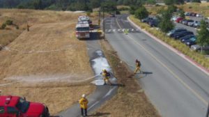
Idledale, Colorado, is like many other western towns. They are enduring a severe shortage of water. The town regularly consumes 26,000 gallons of water each day, but is only able to produce 22,000 gallons a day. The shortfall has recently forced them to purchase water from neighboring Colorado water districts.
Mike Richardson, treasurer of the Idledale Water & Sanitation District, knew that an aerial data analysis could reveal problems the district could fix to save on waste. However, timely surveys would only be obtained through aerial photography, not by dated Google Earth photos. And helicopter surveys would be far too expensive. Idledale WSD contracted with 1UP Drones to identify leaks, cracks, resident waste, and other possible sources of abuse.

Using Drones for Aerial Photography Modeling Assistance
1UP Drones proposed to use UAVs to model the small city of Idledale, then share the data with the Idledale Water and Sanitation District. The entire project was completed in only two weeks. We used our proprietary software to fly the drone capturing approximately 1525 geotagged images. Then, our team stitched them together into four models by neighborhood.
We met with Mike Richardson and shared the results of our work, detailing plant health, topographic data, 2D, & 3D models. After reviewing the data we presented, he met with the Idledale Water & Sanitation District Board to share the results. He remarked to us after our presentation, “This is what I was looking for…stands out like a sore thumb.”
Additionally, there may be follow up Infrared drone flights using the Intel Falcon 8+ for further review of “targeted” pipelines, swamp coolers, and other sites of the City of Idledale. 1UP Drones provided a demo of the capabilities of Infrared and Mike was impressed with what he saw for “phase 2.”

Drones and Topographic Analysis
As climate change and droughts continue to develop, water districts, water companies, landowners with water rights, commercial land developers, construction companies, large HOAs in Colorado, commercial landscape designers, and many others should be exploring the use of UAVs, or drones, for water consumption, water rights disputes, covenant violations, and a multitude of other use cases.

1UP Drones demonstrated here, as we have elsewhere time and again, that UAVs are a very cost effective and timely solution for gathering aerial intelligence. UAV technology allows real-time and photographic/video access to distant, remote, and often dangerous terrain. What human workers can only reach with great difficulty, drones can access in complete safety.
How can 1Up Aerial Drone Services help you with personal drone use, commercial drone use, drone imaging, or training? Call us at 720-476-4101 or fill out the contact form on our website for more information.