- Inventory management
- New 360 panoramas & videos
- AI (Artificial Intelligence) Count for agriculture and livestock
- And much more….
At 1UP Aerial Drone Photography and Video Services, we help your business leverage drones for aerial photography to safely, cost-effectively, and efficiently redefine your marketing and data acquisition methods. Commercial drone use is skyrocketing and promises new business perspectives that were impossible to capture prior to our launch in 2016. We provide the most state-of-the-art drone capabilities and equipment available in the drone world today.
In fact, we have a mantra at 1UP, “the drones are awesome technology, but it’s the software and business outcomes that matter most!” The industry is changing so rapidly that we are always updating and upgrading our drone software capabilities in order to provide advanced capabilities and even better service to our clients. This month we are focusing on our newest capabilities and how we can better serve your business needs.
Create 360-Degree Panoramas and Videos In a Couple of Taps
If it’s true that a picture is worth a thousand words, then how much better is a 360-degree panoramic image or video? Imagine how much easier it would be to manage your project and keep stakeholders informed if everyone could see a visual record of your project progress? We can even save the flight plan to return and record updates to your project. Did those supplies get delivered? Was that crane onsite today? What is the current inventory of materials on hand?
In addition to the standard maps and photos, now we can provide panoramas and videos for you to compare against the latest design plans and/or revisions. Give your stakeholders more reasons to be on board with your project by providing them with an immersive experience that demonstrates current progress, all without requiring them to make a costly trip to the site.
Compare Design to As-Builts – Improve Inventory Management
1UP integration with your BIM applications enables you to connect your workflows to improve communication between the office and the job site. .Let 1UP Drones use our enhanced drone capabilities to help you track and report the total quantity and value of the materials you have on-site. No more timely physical surveys or educated guesses. With drone data, you can now measure materials more efficiently and accurately. Our new inventory management drone capabilities mean less damaged or wasted inventory from overproduction, thanks to reliable, real-time data.
We can combine drone data with your material attributes to generate real-time counts of your stockpiles, calculate volumes, and craft reports displaying the amounts and value of each material. All without timely and costly manual counting and calculating processes.


Get Ready for Growing Season
1UP Drones’ new drone capabilities will also allow us to perform real-time crop scouting, instant tree (or plant) counting, weed analysis, and canopy reporting. Our team can rapidly quantify insured assets and estimate potential yield with high confidence by conducting high definition surveys over hundreds of acres in minutes.
Having data readily available enables your agronomy team to make in-field assessments quickly and efficiently. Insurance claims specialists can accurately quantify crop damage and evaluate an insurance claim in minutes, helping growers to minimize lost time.

Radiometric Thermal Processing – Don’t Freak Over Heat & Those Leaks
We are one of the few aerial services companies who have a certified Level 1 Thermographer on our team and have invested heavily in UAV thermal training.
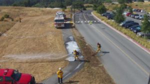
Have you ever wanted to see the unseeable? One of our newest and most commonly requested drone capabilities is the ability to perform Radiometric Thermal Flights and Processing. Now we can examine the unseeable – underground pipelines, water leaks, hidden weather damage, and more.
Examine literally hundreds of acres in just a few days, and see what a detailed physical inspection from walking over the site could not reveal. Now, our drone teams can help you spot problems before they develop, saving you time and money.
Transformer and Tanker Water


Faster Accurate Mapping
When you need fast, accurate mapping services, 1UP Drones can now process calibrated imagery to generate survey-grade mapping that features reliable, repeatable, sub-centimeter accuracy, in a very short window and workflow.
By using the power of cloud processing, we can support up to 10,000 images per map. With support for ground control checkpoints and distributed cloud processing, you can expect high-accuracy results in a fraction of the time to share projects with key stakeholders in a matter of minutes.
Whether performing simple aerial drone photography, construction surveys, inspecting pipelines, real estate drone photography, aiding in surveillance or helping farmers enhance yields, our drones and advanced drone capabilities are powerful business tools.
Let us show you how our drone services can help your business. Call or contact 1UP Drones today.