How the Army National Guard and Weston Solutions Saved Dollars, Time, and Manpower with 1UP Drones Solutions
1UP “Drones” The Winchester Hills Munitions Response Site
A project that is an order of magnitude over-the-top that can result in life or death does not come along often.
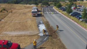
In the 1950s, the “Fish,” otherwise known as the cliffs just outside of St. George, Utah, were used for target practice by the Army National Guard. Recently, 1UP Drones was contracted by Weston Solutions and the Utah Army National Guard to explore these cliffs, searching for 105 mm and 37 mm undetonated munitions. Winchester Hills land development, adventurous rock climbers, and beautiful country combined to challenge Weston Solutions to come up with the “right” approach to keep our land and the citizens of Utah safe.
When they approached 1UP in early 2018 and subsequently contracted us for our 2nd round in late 2019, we were very honored to be selected to the short list of drone companies that they felt could support them with the expertise to help analyze the 90 acres in question, looking for unexploded ordnance.
A Difficult Challenge
According to Chuck Adams, President of 1UP Aerial Drone Services, and one of the members of the team that collaborated on this project, this mission presented a number of challenges for the company, including trying to conduct safe UAS operations in the steep sandstone cliffs of St. George, Utah. The elevations were straight up and scaling the terrain was difficult, if not impossible.
Adding in the weather, large lava rock, prickly cactus, and unexploded ordnance, Adams declared, “This would make for the toughest project we’ve ever had to accomplish using drone-based photogrammetry.”
Despite these challenges, drones proved to be a very useful tool for this particular mission, with this unique set of circumstances.
“Using UAVs was much less of a logistical nightmare than more traditional methods — rappelling from the top of these cliffs would have been a time consuming and costly process,” said Tim Trego, Senior Project Manager, Weston Solutions.
Using drones was probably one of the best methods because we could map an entire ~90 acres in less than a day, flying closer to the ground with the wide variety of terrain. We flew it at a few different altitudes, autonomously and manually, so we could capture every possible angle and dimension for the engineers to analyze. Over the course of two days, we captured more than 2000 images that would need to be reviewed for 105 mm and 37 mm ammo and shrapnel.
The Search Process
Weston Solutions started this project over four years ago by evaluating the land, area of interest, multiple sensors, flight requirements, and companies that could support their needs. Initially, they looked at drones equipped with:
- Photogrammetry
- Multispectral sensors
- Magnetometers
- LiDAR
- FLIR – Thermal imagery
- All technologies required Ground Control Points (GCP’s) for extreme accuracy in locating UXO’s (unexploded ordnances)
The wide range in UAV and sensor configurations results in a variety of data and metadata, and therefore different workflows for Weston Solutions to consider. In the 1UP response, with the help of Russell White, HTS-3D, we demonstrated a successful “Thermal Blind Seed” field test with similar ground surface and metal particles to those anticipated in Winchester Hills. Ultimately 1UP, Weston Solutions, and the Utah Army National Guard landed upon Photogrammetry drones and 3D Modelling as the cost-effective tool of choice.
It took the 1UP crew just two days to capture the necessary data, despite the rough terrain and other factors. 1UP notes that this accelerated the treasure hunt, as after Day 1 it provided the Weston crew with insight into where we might need to look. Day 2 allowed us to make more manual flights (rather than autonomous) and even included a test use case of the capabilities of the Intel Falcon 8+ with FLiR to show what infrared sensors on an enterprise drone might accomplish in the future.
The findings were interesting, but would not have been useful given the expanse of land we were searching. The infrared would have been good for “targeted, very specific” areas of interest, but probably not suited for the entire 90 acres.
The Magic of Photogrammetry
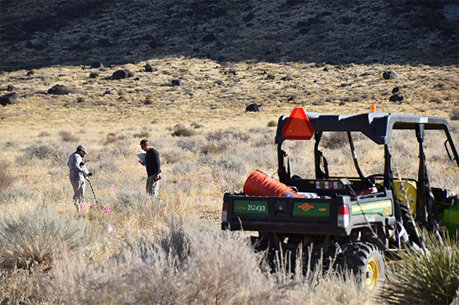
For the flat ground over the four-year project period, Weston Solutions initially used a more traditional method of 4-wheelers with “boots on the ground” metal detectors surveying to get to the “easy” landscape. When it came time to hit the cliffs, the drones were called in for precise aerial photos and drone photogrammetry. This is the science of making measurements from photos.
The result is typically some kind of map, a set of measurements, metadata with longitude/latitude data, and even a 3D model of some object or landscape feature. Many of the maps we use daily were created using photogrammetry and images taken from aircraft or satellites. Now the use of drones is becoming very commonplace for the low cost, speed, and accuracy they can provide.
Mapping with drones is very similar to satellites or aircraft; the main differences being the low altitude a drone can fly, and the tighter control one has over the platform itself. These key differences mean a user can capture much more data and higher quality images. The concept of drone aerial photography in hard-to-reach locations and 3D mapping possesses enormous potential for engineering, construction, agriculture, mining, infrastructure inspection, and real estate. Having a clear, accurate digital collection or 3D model of your project area, complete with measurements, is advantageous for many uses.

Drones are revolutionary and can be an emerging technology for inspections, assessments, and business/operational analysis to make more cost-effective, critical decisions, safer, quicker, and easier. At 1UP, we provide improved information gathering for enhanced operational decisions while streamlining the risk mitigation and assessment of dangerous operations. Whether it be climbing on ladders, scaffolding, or looking for undetonated munitions at Winchester Hills, we hope that 1UP can serve you.
Results of the Weston Solutions & Utah Army National Guard Project
In the past, the team would have been forced to expend precious dollars, time, and manpower in a very dangerous area.
After viewing the results of the drone mission, Tim Trego, Senior Project Manager, Weston Solutions, said, “The 1UP UAV data helped us immensely. The danger of rappelling, and the army of specialized resources we would have had to deploy, made the drones a simple choice.”
As a result of the data collected by 1UP via drones, the following crucial costs were controlled for improved analysis of the area of interest:
- 50% less time in data collection
- 75% less cost in data collection
- 12 “areas of interest” identified where munitions (or seeds) may be present and subsequently searched with high powered zoom lens equipped drones in November, 2019.
- Project staff safety radically improved
- A new technology and technique proven for Weston Solutions and the Utah ANG to integrate into future projects
“The only downside of this drone capture technique was 1UP and my staff complaining of the crossed eyes from closely analyzing over 2500+ photos looking for munitions,” joked Tim Trego, Senior Project Manager, Weston Solutions, Inc. We plan to utilize artificial intelligence and machine learning in the near future for additional projects that 1UP will definitely be involved with.
How Can Drones Help Your Engineering Projects?
Basically, the drone was a map to help the team find areas of interest they might not have seen exploring by foot, 4-wheeler, or rappelling.
Typically, engineering firms like Weston Solutions don’t have the desire to invest the capital to operate an expensive drone, provide the resources for personnel to acquire the FAA Part 107 certifications, and provide for the insurance, risk, and daily expertise necessary.
Therefore, contracting with 1UP Drones makes for a great partnership with forward-thinking engineering firms. 1UP provides the equipment and expertise for safe drone missions, while engineering companies gain highly accurate data for a variety of applications, with minimal personal investment compared to maintaining their own drone operations.
For more information about how 1UP Drone Services can provide your engineering project, call us at 720-476-4101 or contact us online.