Unveiling the Future:
How Drones are Revolutionizing Site Surveys in Construction Planning
By: Richard Armstrong, 1UP Drones Software Engineer – April 2024
This article explores the transformative impact of drone technology on construction site surveys. By utilizing drones, construction companies can obtain high-resolution aerial imagery and topographic data, revolutionizing traditional surveying methods. This piece delves into how drones enhance accuracy, speed up the surveying process, and provide crucial data for informed decision-making during the construction planning phase.
In the ever-evolving landscape of construction, innovation is the key to success. Every phase of a construction project, from conception to completion, demands precision, efficiency, and informed decision-making. Among the groundbreaking technologies reshaping the industry, drones have emerged as a game-changer in site surveys, fundamentally transforming the way construction planning is executed.
The Traditional vs. The Future
Traditionally, site surveys in construction projects involved labor-intensive processes, often relying on ground-based measurements and manual data collection methods. These methods were not only time-consuming but also prone to errors and inaccuracies, leading to costly setbacks and delays. However, with the advent of drone technology, a new era of site surveys has dawned upon us.
Revolutionizing Site Surveys with Drones
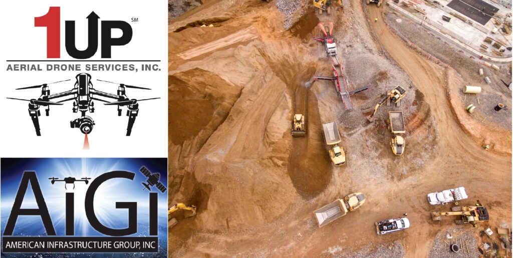
Drones, equipped with state-of-the-art sensors and high-resolution cameras, have redefined the concept of site surveys. By taking to the skies, drones provide construction companies with unparalleled access to high-quality aerial imagery and topographic data. From capturing detailed 3D models of terrain to mapping out site features with precision, drones offer a comprehensive view of construction sites like never before.
Enhancing Accuracy and Efficiency
One of the most significant advantages of drone-based site surveys is the enhanced accuracy they provide. By capturing data from multiple vantage points, drones can create detailed, multi-dimensional maps of construction sites, enabling construction planners to make informed decisions with confidence. Moreover, drones significantly speed up the surveying process, reducing the time and resources required for traditional methods.
Empowering Informed Decision-Making
In the fast-paced world of construction, informed decision-making is paramount. Drones play a crucial role in this aspect by providing construction companies with crucial data and insights necessary for effective planning and execution. Whether it’s identifying potential obstacles, assessing site conditions, or optimizing resource allocation, drones empower construction planners to make strategic decisions that drive project success.
The Advantages of Drone Surveying vs. Traditional Methods
Drone surveying has several advantages over traditional surveying. It is faster, less expensive, safer, more accurate and efficient, and can be used in a variety of environments and conditions.
Drone surveying, powered by LiDAR sensors, offers unparalleled speed, covering large areas quickly and efficiently, potentially reducing surveying time by up to 50%. Moreover, drones can access areas that are difficult or dangerous for human surveyors to reach, enhancing safety on construction sites and reducing the risk of accidents by up to 70%.
Additionally, drones provide a cost-effective solution for site surveys, with potential cost reductions of up to 30% compared to traditional methods. By minimizing the need for manual labor and expensive ground-based equipment, drones offer significant savings in both time and resources.
Furthermore, drones equipped with LiDAR sensors can capture high-resolution data, exceeding the accuracy levels of traditional surveying methods by up to 95%. This precision enables construction planners to make informed decisions with confidence, leading to improved project outcomes and reduced risks of errors and delays.
Conclusion: Embrace the Future with 1up Drones
In conclusion, the transformative impact of drones on site surveys in construction planning cannot be overstated. By leveraging drone technology, construction companies can unlock new levels of accuracy, efficiency, and informed decision-making, ultimately leading to improved project outcomes and enhanced profitability.
As you embark on your next construction project, seize the opportunity to embrace the future with 1up Drones. Our cutting-edge drone services are tailored to meet the unique needs of construction firms, providing unparalleled insights and support throughout the project lifecycle. Reach out to us today to learn more about how we can elevate your construction planning process with our advanced drone solutions. Let’s shape the future of construction together.
Visit our website at www.1updrones.com, email info@1updrones.com or give us a call at 972-808-5185. Don’t miss out on the future of construction. 1UP Drones – Elevating Construction, one flight at a time! 1UP Drones is a proud subsidiary of American Infrastructure Group, Inc. (AIGI).