Aerial Drone Mapping Services for Precision and Efficiency
Aerial drone mapping services have revolutionized how industries conduct mapping and surveying, providing highly accurate, real-time data at a fraction of the cost of traditional methods. By using drones equipped with advanced photogrammetry software and high-resolution cameras, companies can generate topographic maps, 3D models, and point clouds that offer a comprehensive view of their project sites. Whether for real estate development, mining operations, construction planning, utility management, environmental monitoring, or search and rescue operations, aerial drone mapping offers unparalleled benefits in terms of accuracy, efficiency, and cost-effectiveness.
Why Choose Drone Mapping Services?
Drones have become a preferred choice for mapping services due to several key benefits:
- Cost-Effective Solutions: Traditional mapping and surveying techniques can be time-consuming and expensive, requiring extensive manpower and equipment. Drone services significantly reduce costs by minimizing labor, equipment, and time.
- High Accuracy and Precision: Drones equipped with high-resolution cameras and advanced GPS technology can capture precise aerial images and generate 3D maps, topographic maps, and point clouds with exceptional accuracy. This makes them ideal for detailed mapping and surveying needs.
- Rapid Data Collection: Drones can cover large areas in a short time, providing real-time data and high-resolution aerial images that can be quickly processed and analyzed. This speed is crucial for industries that require quick decision-making.
- Versatility Across Multiple Industries: Aerial drone mapping is versatile and can be customized to meet the needs of various industries. Whether it is civil engineers creating high-resolution 3D models or real estate developers needing detailed site maps, drones offer flexible solutions.
- Reduced Risk to Human Operators: Drones eliminate the need for human operators to navigate potentially dangerous terrains or inaccessible areas, thereby reducing risk and enhancing safety in the field.
Industries and Use Cases for Aerial Drone Mapping Services
Drone mapping services have applications across a wide range of industries. Here are some of the most prominent use cases:
Construction and Civil Engineering
Aerial drone mapping is invaluable in construction and civil engineering projects. Drones provide accurate and high-resolution 3D maps and topographic mapping that help project managers and civil engineers monitor progress, manage resources, and ensure safety compliance. The data collected can be used to create high-precision 3D models of the site, facilitating better planning and coordination among teams.
Real Estate Development
For real estate developers and agents, drone mapping services offer a competitive edge by providing potential buyers with comprehensive aerial views of properties. High-resolution aerial images and 3D models created using drone data help in showcasing the exact layout, size, and landscape features of a property, enhancing marketing efforts and accelerating sales.
Agriculture and Environmental Monitoring
In agriculture, drones provide efficient mapping solutions that help farmers monitor crop health, manage irrigation, and plan harvests. Environmentalists use aerial drone mapping services to assess natural habitats, track wildlife, and monitor environmental changes. Drones equipped with infrared sensors can even detect plant stress, enabling more proactive farming practices.
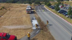
Search and Rescue Operations
Drones are becoming an essential tool in search and rescue operations. With their ability to quickly cover large areas and capture high-resolution images, drones equipped with thermal imaging can locate missing persons or identify hazardous conditions that might not be visible to the naked eye. Real-time mapping and surveying help rescue teams plan their efforts more effectively.
Mining and Quarrying
In the mining industry, aerial drone mapping services are used for volumetric analysis, pit monitoring, and safety inspections. Drones can easily access hard-to-reach areas, providing detailed data on site conditions and enhancing operational efficiency.
Urban Planning and Smart Cities
Urban planners use drone mapping to create accurate maps and 3D models of cities, helping them understand the current landscape and plan future developments. High-resolution aerial images assist in planning infrastructure like roads, parks, and utilities, ensuring sustainable growth and development.
How Our Aerial Drone Mapping Services Stand Out
At 1Up Drones, we leverage cutting-edge drone technology and photogrammetry software to deliver top-tier aerial drone mapping services. Our team of certified drone pilots ensures that every project is conducted with precision and safety in mind. We offer customizable mapping solutions tailored to the specific needs of each client, whether they require high-resolution 3D models, point cloud data, or detailed topographic mapping.
Our drone services include:
- High-Resolution Aerial Images: Capture detailed images for enhanced site assessments.
- 3D Models and Point Clouds: Create accurate 3D models and point clouds for construction, real estate, and more.
- Topographic Mapping: Generate precise topographic maps for planning and design purposes.
- Volumetric Calculations: Conduct volumetric calculations for mining, construction, and resource management.
- Real-Time Data Analysis: Get actionable insights quickly with our real-time data processing capabilities.
Why Work with 1Up Drones?
1Up Drones is a trusted name in the industry, known for delivering high-quality aerial drone mapping services that are accurate, efficient, and cost-effective. Our expert team is committed to providing clients with reliable mapping solutions that meet their specific needs and help them achieve their goals.
Key Features:
- Certified Drone Pilots: Our team consists of certified and experienced drone pilots who adhere to the highest safety standards.
- Advanced Technology: We use state-of-the-art drones equipped with the latest cameras and sensors to deliver the best results.
- Customized Solutions: We offer tailored services to suit the unique needs of various industries and projects.
- Fast Turnaround: Our efficient workflows ensure that clients receive their mapping data quickly, allowing them to make timely decisions.
If you’re looking for professional and reliable aerial drone mapping services, 1Up Drones is here to help. Our comprehensive mapping solutions provide accurate data and insights that can enhance decision-making and improve project outcomes across various industries. Contact us today to learn more about how we can assist you with your drone mapping and surveying needs.