1UP Aerial Drone Services, Inc., headquartered in scenic Golden, Colorado, provides services to a wide range of industries including Commercial Real Estate, Land Development & Construction, Insurance, Forensic Sciences, Security Services, Oil & Gas, Precision Agriculture, Surveying, Energy, Mining, Utilities, and Professional Digital Marketing.
We provide unique insights into your business operations with use of today?s modern drones.
The integration of drones into the national airspace helps our clients drive costs from data gathering, analysis, and scouting tools while increasing revenues through improved marketing, less costly aircraft deployment, and logistically impossible airspace restrictions. The simple truth is small multirotor drones can fly lower and closer to your project than traditional aircraft to capture more useful and detailed information.
The services we provide are cost effective, safer, faster, and more accurate than traditional methods of stale satellite or Google Earth aerial data and information.
Our team consists of 50+ years of flying, inspection, and photography experience. We surround our customers with subject matter experts in post-production video editing and rendering, animation, structure-from-motion, high-tech computing, cyberinfrastructure, data archival, computer storage and networking. We round out the team with a cadre of nationally recognized ?data scientists? who can assist our clients in analyzing untapped, new information collected by unmanned aircraft.
Meet the 1UP Drones Team
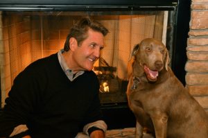
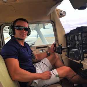
Chuck ?
1UP Land Liberator and 3D Aerial Memory Maker (aka CEO), FAA Part 107 Certified Pilot, and tenured IT, Cloud industry veteran who spent 23 years in the high tech industry.
I see the intersection of what our clients can do with the commercial use cases that unmanned aircraft represent. Combine drones with high quality photography, videography, 3D modeling software, and we jumped at the opportunity to integrate these services. We are driving cost effective, revenue generating solutions that augment our client?s GIS surveying, digital photography/videography, ?drone-vertising?, business inspection and data acquisition strategies.
Layering 3D Models of geospatial information over large commercial land developments to create subdivisions from raw land, or reconstructing accident scenes for forensic science evidence gathering using ?drone flyovers? with layered animations are examples of the ?industrial strength? applications of the technology and services provided by 1UP.
He is a well-respected executive speaker on Emerging Technology, Cloud, IoT, and Business Development. Chuck enjoys skiing, racquetball, and the outdoors. He holds a Bachelor?s degree in Business Administration from the University of Kansas and is married to Kimberly. They have 3 daughters, 1 son, and 3 grandchildren.
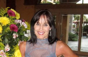
Kimberly –
1UP VP, Operations has responsibility for overall project planning, marketing, finance and ?fanatical? customer satisfaction. She holds a Bachelor of Science degree in Sociology from Oklahoma State University. Before embracing her greatest career accomplishment in raising 2 wonderful daughters Kimberly was a juvenile probation officer (watch out fellas).
I am excited and blessed to be part of this incredible, emerging industry! I look forward to assisting our customers and building relationships for life.
In addition to 1UP Operations, Kimberly is a volunteer for CASA of Jefferson County. She plays the piano for two of Bessie?s Hope nursing homes and enjoys skiing, hiking with her two ?kids? (aka 2 year old Golden Doodle and a 6 year old Lab), and spending time with family and friends.
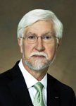
Dr. Rafert –
Commonly known as the 1UP ?secret weapon?. Dr. Rafert brings value to our clients through his innovative initiatives and provides integration of 1UP solutions using ?data actualization? and ?actionable data? intelligence. In other words, we assist our clients in taking what we capture in photographs, videos, sensors, and other means and make this data useful in making critical business decisions. He has served on the US Army Science Board, and was the scientific and technical founder of the USAF Hyperspectral initiative.
Bruce is a subject matter expert in astronomy, structure-from-motion, high-tech computing, cyber infrastructure, data archival, computer storage and networking. He rounds out the team as a nationally recognized ?data scientist? who will assist our clients in analyzing untapped, new information collected by unmanned aircraft. He holds a Bachelor?s of Science from Case Institute of Technology and a PhD from the University of Florida. His expertise and citations can be found at https://scholar.google.com/citations?user=otq94awAAAAJ&hl=en&oi=ao.
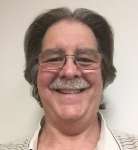
Ron –
Scary pics! By his profile you may be able to gauge Ron?s expertise at 1UP. FLIR equipped drones and Thermography! The possible applications for thermal imagery are growing and endless. Ron is a FAA Part 107 Certified Pilot and a Level 1 ITC Certified Infrared Thermographer. He regularly provides inspection projects involving solar panels, electrical infrastructure, commercial buildings/roofing, pipeline monitoring, precision agriculture, security, traffic monitoring, and SAR (search and rescue). I like to say he ?runs hot and cold?!
Ron is a native of Nebraska and tells us last winter he had the opportunity to be a ?drone rancher? helping a farmer with livestock inventory management while counting heads of cattle with a drone. He has also recently had some adrenaline rush flights over the beautiful coast of Oregon while chasing seagulls (or was it the other way around). In his off hours you will find him enjoying the great outdoors, living the ?lake life?, hiking the mountains, fishing and camping with his wife and dogs.

Chuck –
A seasoned veteran who has flown 500+ UAV flights and is Part 107 Certified! His equipment includes an 8 propeller DJI S1000, an Inspire 1, and a Panasonic GH4 camera with Lightbridge 2 for extremely professional quality aerial video and photography projects.
?Flying is my art and I love creating new and amazing perspectives of everything I fly. The aerial photography and videography that I capture and produce is breathtaking.?
Chuck provided aerial drone services for a client who listed a 25 acre equestrian property in Castlerock, Colorado. The coverage also included the interior of the home. Chuck added a western cowboy theme videography and within 24 hours a prospective buyer in Michigan saw the video online, flew to Denver, and bought the property resulting in a $2M sale. Chuck also specializes in construction aerial photography. He has done numerous custom projects for architects in the site planning process who wish to see the views from various heights, angles, and locating obstructions in the planning process.
Jacob –
One of the Top 50 MultiGP pilots in the USA who has 10 years of flying experience. He holds his Section 333 Exemption and is an extremely talented technician solving almost every UAV operational challenge. Lately you will find him hanging out with his Inspire 1, Phantom 3, or multiple racing drones. His ?highest? achievement in his drone career was in June 2015 when he filmed Mount Humboldt after 4 hours of tough hiking the brutal 14?r. He then flew a total distance of over 18,000 feet! Jacob also enjoys St. Mary?s Glacier and filming many other beautiful locations in Denver and the Front Range.
He is a specialist for 3D Maps, Pre Construction 4D mapping, Commercial Real Estate, Land Development, and Large HOA?s.
When he is not flying, Jacob is an avid outdoorsman who enjoys hiking, biking, swimming, competitive FPV Drone Racing, Inline Hockey, and Disc Golf.

?Perric? –
Not only a specialist in flying UAS Drones, Perric also has his recreational pilot?s license (and soon to be private pilot). He is an accomplished ?wingman? achieving his Section 333 Exemption and FAA Part 107. When not flying his plane he enjoys his Phantom 3 and custom built platforms shooting 4K videos over the frozen tundra, lakes, and waterfalls in the Colorado and Montana winters. With his love for the outdoors, he also specializes for 1UP in GIS projects (3D Modeling) and large Colorado ranches, agriculture, wildlife management, and the oversight of controlled burns and fire mitigation.
For our complex projects, Perric is another pilot and technical genius who has expertise in 3D mesh, Autodesk Point Cloud, 3D & 4D mapping, surveying, and land development. You?ll find Perric kayak fishing, skiing or anything involving physical fitness when he?s not flying his aircraft.