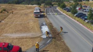
Drones have been around for decades. However, their presence in everyday life is much larger in recent years. And, even more so since the start of the pandemic. Arguably, one of the most vital uses for drones is helping with Search and Rescue (SAR). As technology advances in drones as well as other SAR technology, they have become key components for these missions. We would like to highlight some of the advances in this monthly article. 1UP has unfortunately been involved in two SAR’s since opening its doors five years ago. 1UP Search & Rescue News
Public safety agencies, such as law enforcement and fire departments, heavily utilize drone SAR technology. But in fast paced, life or death SAR incidents, it’s not always about the drone and sensor. To complete the workflow, many government agencies are now considering software and hardware to integrate into the incident management. For example, fleet management and live streaming with AirData. Or, 1-touch backup in the field to easily secure critical data, create redundancy and automate file organization by flight & location using the Gnarbox Drone Edition. Therefore, this can often be what makes these efforts successful and lives saved.
Of course, drones can scan and photograph large areas quickly. Then, the accompanying field software and hardware eliminates critical minutes/seconds in the searches and rescues. The typically high res images can then be saved and analyzed for optimal, efficient results. Examining the use cases and technologies involved will provide perspective on the vitality of this technology for the future.
What is the Search and Rescue protocol?
For any SAR operation, very specific steps must be followed. This structure is defined by the National Incident Management System (NIMS). These protocols are well-detailed for every type of SAR team which include: mountain rescue, ground search and rescue, combat search and rescue on the battlefield and air-sea rescue over water.
NIMS is a national approach, coordinated by FEMA. They provide a comprehensive guide for all incident response and management for all government, nongovernmental organizations and private sector organizations to follow. View the guide here.
What data is collected by drones in SAR efforts?
Both video and photos are collected by drones for search and rescue missions. Some drones will also utilize thermal cameras to help detect people, depending on the situation. While video may seem like the best tool for these efforts, high resolution photographs are sometimes more vital.
Taking a video will decrease the pixels making it harder to detect clear details. According to Gene Robinson, the “grandfather of search and rescue drone operations”, drone still imagery can produce a photo of about 20 megapixels. Comparatively, even a 4K video will only equal about 8 megapixels. Clearly, it makes more sense to take still images for everyone on the SAR team to study.
That being said, videos can be very useful to provide context to the landscape the drone is covering. It is important for a drone to be able to mark coordinates so the EXIF data, or “geotagging” is critical. Furthermore, each member of the team can see common surroundings. And, everyone is on the same page as the search begins. The bottom line is that drones cover such a large area efficiently and capture every second. This has made them the integral part of search and rescue that they are today.
How to quickly classify Search and Rescue photos?
These high resolution images can often be what finds the missing person in search and rescue outings. Teams can now observe, upload, review, and scan within minutes in real time. These missions are typically very time sensitive where every second counts.
There are two relatively new solutions that 1UP strongly recommends for SAR, incident command, LEO and all 1st responders: Airdata and Gnarbox. We have recently formed a partnership and now have a formal authorized reseller/integrator relationship with both companies.
Airdata
We found Airdata to be a simple, user-friendly, yet powerful way to keep track of a team of pilots and equipment. It automatically captures drones flights and pilot data to meet compliance requirements. It also discovers early signs of problems to prevent surprises in the air as well as effortlessly track maintenance requirements. But, MOST IMPORTANTLY, Airdata can provide live streaming anywhere. Incident command and SAR drone operators have a reliable, fast, and easy to use live streaming. The Airdata Live Streaming service works over the internet and is designed for cellphone and mobile hot-spot speeds. No special hardware is necessary and setup is quick and easy.
- SHARE YOUR FLIGHT
- Select what information is shared
- Chose who to share the flight with
- Create a unique sharing link
- COLLABORATE WITH OTHERS
- Troubleshooting in-flight issues
- Identify areas with high levels of interference
- Showcase your flight
Gnarbox
Gnarbox is for those incident SAR operators who may be upset with the speed and security of moving files from the field to the cloud when every second counts. This rugged backup device doesn’t require a laptop or cell phone to backup SD cards, check for data corruption, organize (by flight and location) and review files or upload to the cloud. Unlike the laptops or tablets currently being used in the field, GNARBOX 2.0 Drone Edition is water resistant, pocket-sized and has consistent high speed transfers and battery life.
Furthermore, terrain can be very dangerous while searching for a missing person. Drone photos can provide context to what equipment will be needed. For example, if a person fell off a cliff, a helicopter may be necessary. Or a drone with a drop mechanism may be able to drop a 2-way radio, or a small “supply package”.
Top SAR equipment
Law enforcement, fire departments, and many other organizations may need to purchase search and rescue drones and other equipment. The following drones are the top choices for these missions all available at 1UP Drones or other retailers.
Autel EVO2 640T or 640 Dual Rugged Bundle
Price: $6,900.00 to $9,998.00
The Autel EVO2 640T is arguably one of the best drones for SAR. This product supplies photos with resolutions up to 640×512, 8K video, multiple temperature measurement modes, real time video distribution and many other features.
This drone is used for both law enforcement SAR missions as well as fire departments. Members of those teams can detect danger, see the terrain and easily identify missing people or those trapped.
For those that need the “Made in the USA” version check out the Autel 640 Dual Rugged Bundle.
Autel Live Deck
Price: $449.00
The Autel Live Deck is compatible with the drone listed above as well as the Autel EVO1. This drone accessory can easily pair and gain access to multiple video outputs. This easy to use technology is vital for quickly pulling up images for SAR and communication with incident command.
DJI Matrice 300 RTK
Price: $11,099 (plus cost of sensor)
The DJI Matrice 300 RTK is another great drone option for SAR. This product enables transmission up to 15km away and supports triple channel 1080p video, pilot handoffs, smart pin and track, live mission recording along with several other features.
BRINC Lemur
Price: Request quote
The BRINC Lemur are drones “dedicated to protecting lives in dangerous situations”. This clearly makes them an ideal product for SAR. These drones are very durable and can last in temperatures ranging from -20 to 120 degrees fahrenheit, they are waterproof, have an encrypted video transmission system, as well as other important features. These products have a powerful control and video signal allowing the operator to command from blocks away.
BRINC Lemur products are already used by law enforcement, fire departments, hazmat and the military.
Gnarbox
Price: Varies
Gnarbox has several products available on 1UP Drones website that can all be used in SAR. Gnarbox created rugged, reliable backup devices that can be paired with drones and utilized without a laptop to backup SD cards, check for data corruption, organize and review files or upload to the cloud. They are weatherproof, easy to use, charge quickly and so much more. This strong, reliable product is ideal to backup all information while working SAR.
Gnarbox has an eBook with information for drone operators to learn the best practices to scale drone data management systems effectively. This is helpful for those looking to reduce pilot error, prevent data loss, and save on daily operational time.
Unfortunately, search and rescue missions are unavoidable. When law enforcement and fire departments have the correct equipment and technology, many more lives can be saved. Drones are proving vital for these missions and as their tech progresses, the public will be in even better hands.