Revolutionizing Construction, Utilities, and Infrastructure with Advanced Drone LiDAR Mapping and 3D Modeling
Written by Richard Armstrong – 1UP Drones Software Engineer & Drone Expert – August 2024
The landscape of construction, utilities, and infrastructure projects is rapidly evolving, driven by advancements in technology. Among these, drone services stand out, offering unprecedented precision, efficiency, and cost savings. At the forefront of this revolution is the use of advanced LiDAR (Light Detection and Ranging) and 3D modeling capabilities. This article delves into the technical aspects of drone LiDAR mapping and 3D modeling, highlighting their transformative impact on these industries.
The Technology Behind Drone LiDAR Mapping and 3D Modeling
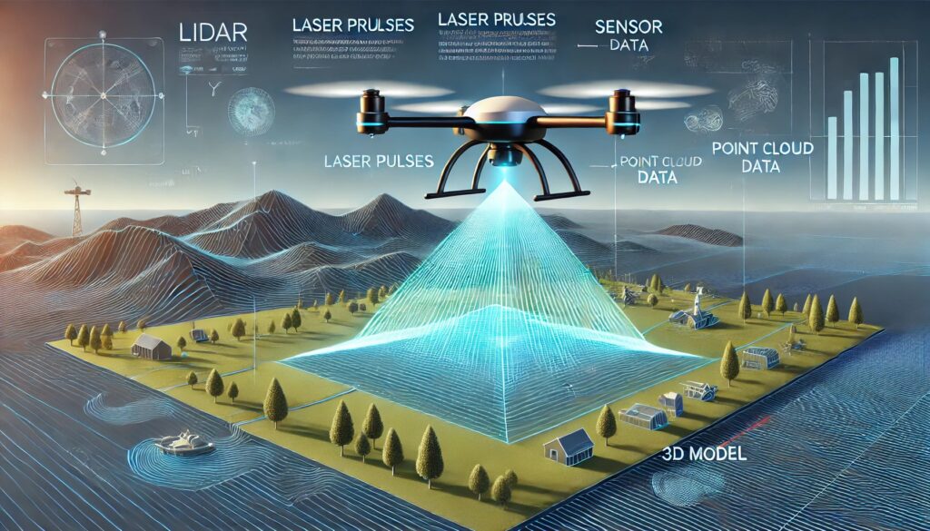
LiDAR technology utilizes laser pulses to measure distances, creating highly accurate, three-dimensional representations of the surveyed area. Mounted on drones, LiDAR systems can capture vast amounts of data quickly and with unparalleled precision. When combined with advanced 3D modeling software, this data can be transformed into detailed maps and models that provide valuable insights for various applications.
Key Technical Advantages:
- High Precision and Accuracy: Drone LiDAR systems can achieve centimeter-level accuracy.
- Rapid Data Acquisition: Drones can cover large areas quickly, reducing the time required for data collection from weeks to days.
- Accessibility: Drones can access hard-to-reach or hazardous areas without putting human workers at risk.
- Comprehensive Data Collection: LiDAR captures data points from all surfaces, including vegetation and ground levels, providing a complete picture of the terrain.
- Integration with BIM: 3D models created from LiDAR data can be seamlessly integrated into Building Information Modeling (BIM) systems, enhancing project planning and management.
Applications in Construction
In the construction industry, drone LiDAR mapping and 3D modeling offer several critical benefits:
- Site Analysis and Planning: Detailed topographical maps and 3D models help in assessing site conditions, identifying potential issues, and planning construction activities with precision.
- Progress Monitoring: Regular drone surveys enable real-time tracking of construction progress, ensuring projects stay on schedule and within budget.
- Quality Control: High-resolution models allow for meticulous inspections, identifying deviations from design specifications early.
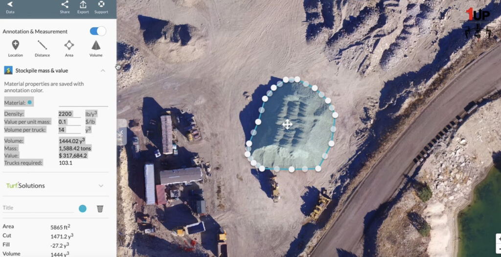
- Cut and Fill Analysis: Accurate cut and fill volume calculations are essential for earthworks. Drone LiDAR provides precise measurements, reducing the risk of errors and ensuring efficient material usage.
Applications in Utilities and Infrastructure
For utilities and infrastructure projects, drone LiDAR mapping and 3D modeling are game-changers:
- Asset Management: Detailed models of infrastructure assets, such as power lines, pipelines, and roads, facilitate efficient prioritization, maintenance and management.
- Damage Assessment: After natural disasters, drones can quickly survey affected areas, providing critical data for damage assessment and repair planning.
- Environmental Monitoring: LiDAR data helps in monitoring environmental changes, such as erosion or vegetation growth, crucial for infrastructure sustainability.
- Mapping Hollow Vertical Objects: Drones equipped with LiDAR can accurately map hollow vertical objects like chimneys, towers, and silos, providing essential data for structural assessments and maintenance planning.
LiDAR Use Cases
Inspection of Hard-to-Reach Areas:
Our LiDAR equipped drones at 1UP Drones are used for inspecting difficult-to-access structures such as rooftops, HVAC units, cell towers, solar panels, and electric transmission lines. These inspections help mitigate risks and reduce costs by leveraging advanced UAV technology to perform tasks that would otherwise be dangerous or expensive for human inspectors.
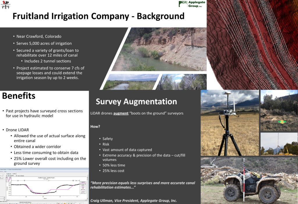
Cut and Fill Volume Estimation:
For a 15-mile-long ditch lining and reshaping project, 1UP Drones utilized LiDAR to develop LAS point clouds of bare earth surface data. This technology provided precise cut and fill volume estimates, leading to more accurate canal rehabilitation plans and fewer surprises during execution, resulting in 25% lower costs, 50% less time, and significantly enhanced safety for the canal rehabilitation project
Infrastructure Assessment:
1UP Drones has been instrumental in revolutionizing infrastructure assessment. Our drones are used to evaluate and monitor critical assets such as towering buildings, expansive bridges, and vast utility networks. This technology provides comprehensive data that improves the accuracy and efficiency of infrastructure maintenance and development.

Highway Construction Projects:
A major highway construction project utilized drone LiDAR to perform initial site surveys and ongoing progress monitoring. The data collected helped in accurate cut and fill calculations, optimizing earthmoving operations and reducing material costs by 15%.
Utility Line Inspection:
A utility company employed drones with LiDAR to inspect miles of power lines. The high-resolution data allowed for the early detection of potential issues, reducing maintenance costs and preventing service disruptions. The 3D models generated also helped in planning future expansions.
Post-Disaster Assessment:
Following a major flood, a city used drones to survey the affected areas. The LiDAR data provided a detailed view of the damage, enabling efficient allocation of resources for recovery and rebuilding efforts. This approach reduced the assessment time from several weeks to just a few days.
Wind Turbine Inspection:
Drones equipped with LiDAR sensors can inspect wind turbines efficiently, reducing the need for manual inspections. This technology ensures safe and reliable operations by autonomously positioning the drone in front of the turbine, thereby minimizing costs and risks associated with manual inspections.
Forestry and Agricultural Management:
In forestry, drones with LiDAR sensors create accurate geospatial data and detailed 3D terrain maps. This data is valuable for monitoring tree health, crop management, and planning in construction and mining. The precision of LiDAR technology helps in understanding topography and vegetation coverage, enhancing the efficiency of these industries.
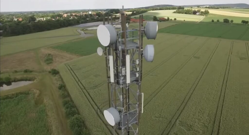
Cellular Tower Inspection:
Climbing cellular towers for inspection is no longer necessary. Our LiDAR-equipped drones can safely and effectively inspect cellular towers by detecting and avoiding obstacles. This capability allows for more frequent and thorough inspections, improving the safety and performance of the towers.
Why Choose Our Company for Drone LiDAR Mapping and 3D Modeling Services?
At 1UP Drones, we pride ourselves on delivering top-notch drone services tailored to meet the unique needs of our clients in construction, utilities, and infrastructure. Here’s why we stand out:
- Cutting-Edge Technology: We utilize the latest LiDAR systems and 3D modeling software to ensure the highest quality and accuracy.
- Expert Team: Our team comprises experienced professionals with deep expertise in drone operations, surveying, and data analysis.
- Extensive Experience: We have extensive experience using LiDAR for clients and a proven track record of delivering success and value.
- Comprehensive Solutions: From initial site analysis to ongoing monitoring and maintenance, we offer end-to-end solutions.
- Customer-Centric Approach: We work closely with our clients to understand their specific requirements and deliver customized services that drive value.
Conclusion
Drone LiDAR mapping and 3D modeling are revolutionizing the way construction, utilities, and infrastructure projects are executed. By embracing this cutting-edge technology, decision-makers can achieve greater efficiency, accuracy, and safety. As a leader in drone services, 1UP Drones is uniquely positioned to help you leverage these benefits. Contact us today to learn how we can assist you in transforming your projects with our advanced drone solutions.
Embrace the future of LiDAR mapping and 3D modeling drone services with 1UP Drones.
Visit our website at www.1updrones.com, email info@1updrones.com or give us a call at 972-808-5185. 1UP Drones – Elevating drone LiDAR services, one flight at a time! 1UP Drones is a proud subsidiary of American Infrastructure Group, Inc. (AIGI).
References
1. Inspection – 1UP Drones
[Elevating efficiency how drones revolutionize asset inspection in the utilities sector]
2. 1Up Aerial Drone Services, Inc.
[Use Case Archives – 1UP Drones]
[Commercial Drone Use Case Archives – 1UP Drones]
3. Drone Use Case Archives
[Drone Use Case Archives – 1UP Drones]
[Commercial Drone Use Case Archives – 1UP Drones]
4. Blickfeld
[“Drone with LiDAR: Real-time 3D Mapping and Inspection”]
[“Drone with LiDAR: Real-time 3D Mapping and Inspection”]
5. Ouster