


Description
About Wingtra One Gen II
Get your survey data faster
The WingtraOne mapping drone’s unique set of features empowers you to minimize your time flying and get more work done, be it another project in the field or analyzing your data at the office.
Efficient fixed-wing flight
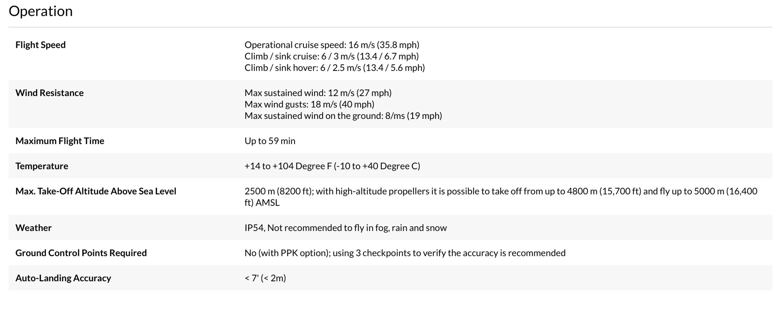
Fly at 16 m/s (36 mph) for up to 59 minutes per flight for large coverage.
No more GCPs, checkpoints only
With an onboard high-precision PPK GNSS receiver you no longer need to lay out ground control points (GCPs). Use as few as three checkpoints to verify your map quality.
Lower image overlaps
High quality optics means you can reconstruct your map reliably even with lower overlaps. This means more new ground covered per flight line and maximum coverage per flight.
Data collection speed
Numbers refer to our coverage and labor cost calculator and the most widely used competitor drone and camera models. This number can vary depending on factors such as overlap, camera model and altitude. The model takes into account data collection only. Flight planning, setting up GCPs, data processing, time to relocate between flights are not taken into account in this model.
• Up to 11x faster than multicopter drones
• Up to 2x faster than standard fixed-wing drones
Survey more in a single flight
Whether it’s a highway, an industrial complex or a mine, you can now take on large projects that were previously impossible to map with a drone. And it takes you just a few hours.
Cut your costs
Faster data collection and expanded coverage mean fewer people in the field for less time, lowering the man-hour costs associated with data collection.
A mapping drone for anywhere
Thanks to its VTOL design, WingtraOne can take-off and land almost anywhere-even in confined spaces or on rough terrain. This enables you to collect data where other drones cannot.
WingtraOne’s camera never comes into contact with the ground, meaning no debris scratching your camera lens and thus a longer equipment lifetime.
A drone you can rely on
No matter the conditions, WingtraOne operates safely and delivers high-quality data, consistently.
Engineered and assembled in Switzerland
Each fixed-wing drone is subjected to more than 300 rigorous tests to ensure the highest quality standard.
Industry-leading reliability
More than 100,000 flights and 6 years of continuous testing and enhancements will ensure maximum up-time for your operations.
Predictive self-diagnosis
WingtraOne self-diagnosis component malfunctions using advanced machine learning algorithms based on thousands of flights.
Automated safety checks
Before every flight, the WingtraOne automatically checks its own sensors and actuators to make sure you can fly safely.
Sharp results, even in wind
WingtraOne can safely fly and capture data in sustained winds up to 12 m/s (27 mph) and gusts up to 18 m/s (40 mph).
12 m/s (27 mph) sustained wind at cruise height (120 m, 400 ft) corresponds to approximately 8 m/s (19 mph) measured on the ground with the wind measurement tool provided in the Wingtra pilot box.
Tipping expectations
Strong winds and uneven ground can cause the WingtraOne to tip over. Generally, this is not a problem since only some scratches might occur while the robustness of the system is not compromised.
Landings in the home point zone are always very accurate and predictable compared to belly landings. In light winds and calm conditions, WingtraOne lands smoothly on its tail.
Software for a smooth workflow
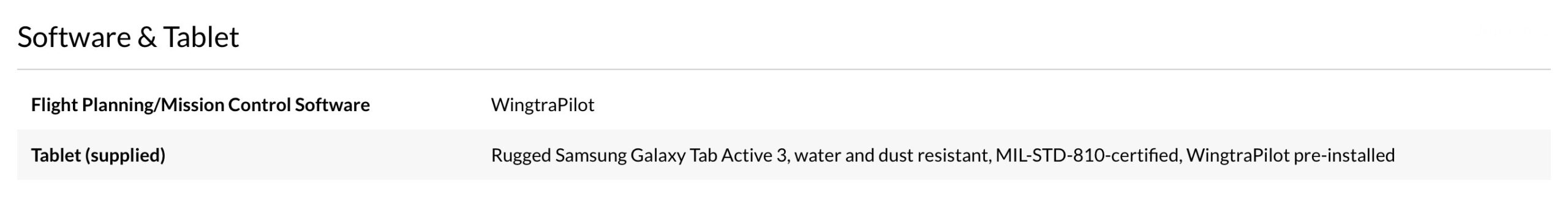
WingtraOne comes with a rugged tablet and a feature-rich, easy-to-use flight planning app, so you can perform successful data collection from day one.
KML import
For a seamless mission, simply import KML files directly from GIS programs. WingtraPilot will construct the optimal flight path to cover the area.
Corridor mapping
The feature enables fast, efficient coverage of long, narrow stretches such as roads, pipelines or rivers.
Terrain following
Safe and effective mapping from steady altitudes in even the most mountainous areas thanks to global terrain models or your own custom elevation data.
Pause and resume
At any time during flight, you can either pause and resume the survey mission or prompt the drone to fly back to its take-off location automatically.
Offline maps
No internet connection in the field? No problem. You can always download offline maps in advance while you’re still connected to the internet.
Battery swap and resume
Automatically splits large missions, pausing flight and resuming after the batteries have been swapped.
World-class support
Integrating new technologies into existing workflows may seem as a challenge at first, but Wingtra’s top-rated customer support is here to help you every step of the way.
Top-performing mapping drone
Survey specialists in various industries rely on WingtraOne for better mapping and faster data collection.
Find out why Wingtra is unmatched
See how to use mapping drones for brilliant surveying results.
Ready to fly in five minutes
The WingtraOne drone comes with a tablet featuring WingtraPilot, the built-in app for easily managing data acquisition. The intuitive app includes various ways to prepare flight plans as well as monitor and review missions during flight.
5 min setup
Take off in less than five minutes, including drone setup, all pre-flight steps and planning of a simple mapping mission.
Pre-flight checklist
WingtraPilot guarantees full functionality of the drone before the flight by running background checks like battery health, GPS reception and test images.
Fully autonomous
Automated launch, in-flight data collection and landing without human interaction.
Pause and resume
Pause the survey mission at any time to make the drone loiter in the air, or trigger return to home (RTH), causing the drone to fly back to its take-off location automatically.
From both of these states at any time, you can resume the survey mission, and the drone will start capturing images from where it stopped.
Manual take-over with in-app controls
Take manual control of the drone at any time during landing. Use the intuitive controls on the tablet to adjust its position mid-air and land safely.
Real-time monitoring
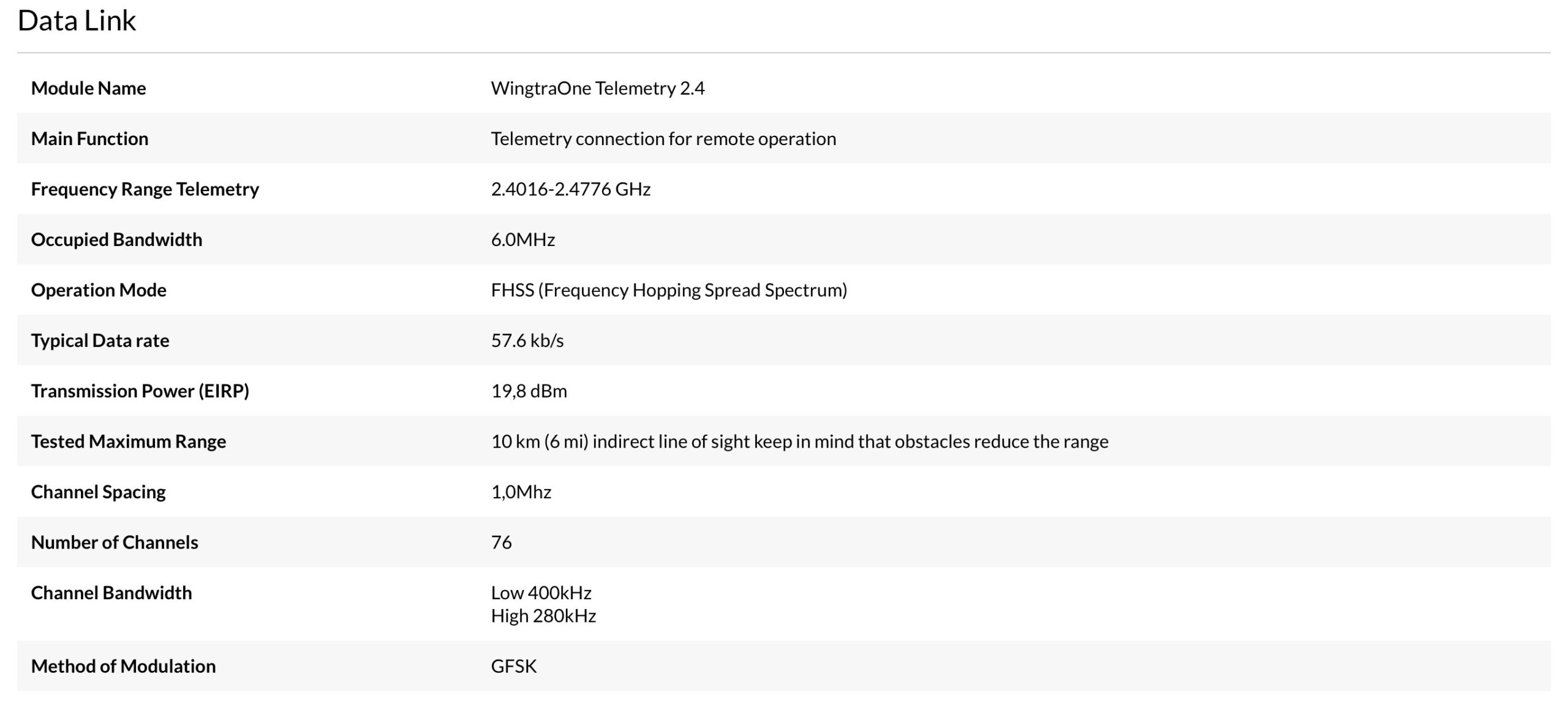
Displays information like flight location, altitude and mission progress from a range of up to 10 km (6 mi).
Smart voice
Provides you with comprehensive audio feedback during the mission.
Use one drone for all your mapping missions
With swappable cameras and propellers, and advanced flight planning features, you are able to collect different types of data in any environment.
Camera swap
Swappable camera with a single standard USB-C interface. Change between RGB, oblique, and multispectral cameras within minutes.
High-altitude propellers
Optional propellers allow take-off at altitudes at up to 4800 m (15,700 ft) AMSL and data collection at altitudes of up to 5000 m (16,400 ft) AMSL.
Corridor mapping
Fast, efficient coverage of long, narrow stretches. For road construction or inspection; railway track, pipeline and power line inspection, and environmental research.
Beyond visual line of sight (BVLOS)
Full mission capability even without a connection to the ground station.
Advanced mission planning
Multi-area planning and zero overlap for population counting algorithms.
Speed up your workflow
WingtraPilot and WingtraHub have been developed with many smart features to make your data collection faster, safer and more convenient.
On-site inspection
All aerial images and geolocation information is stored on a single SD card and can be inspected in the field on the WingtraPilot tablet for early quality checks.
Integrated PPK post-processing
WingtraHub is our integrated image geotagging software. If you have a WingtraOne with a PPK module, the high-precision PPK processing will give you centimeter-accuracy geotags for flight images. WingtraOne images can be geotagged in any Earth-centered, Earth-fixed coordinate system such as WGS84.
Saved mission
For time saving and consistent results from recurring surveys, saved missions can be loaded with a single click.
Multi-flight geotagging
Allows georeferencing of multiple flights at the end of the day, saving time in the field.
Single SD card workflow
Eliminates risk of mismatched or lost data even for the PPK workflow.
Stay confident even in tough conditions
Engineered in Switzerland, WingtraOne offers the highest quality standards and is extensively used in various environments, from glaciers in Greenland to desert mines in Namibia.
Payload protection
WingtraOne’s camera never comes into contact with the ground, protecting it from abrasion, dust, dirt and snow, especially on rough terrain
Terrain following
The terrain following function relies on global terrain models and allows safe and effective mapping from steady altitudes even in the most mountainous areas.
Absolute flight altitude, flight height above the ground and terrain elevation are graphically displayed in WingtraPilot.
Predictive self-diagnosis
WingtraOne diagnoses component malfunctions for batteries, motors and servos using advanced machine learning algorithms based on data from thousands of flights.
Wingtra One Gen II Features
- Ready to fly in five minutes
- Use one drone for all your mapping missions
- Speed up your workflow
- Stay confident even in tough conditions
- Fly everywhere, safely
- Achieve high data quality
- Trust your equipment
What’s in the box:
- Wingtra One Gen II Mapping Drone
- Tablet with Flight Planning Software WingtraPilot
- Telemetry Module (2.4 GHz)
- 4x Batteries
- Charging Station
- Anemometer
- microSD Card Reader
- Pair of Spare Propeller
- 2x Side Stands
- Middle Stand
- Torx Screw Driver T10
- Torx T10 Key
- Carrying Sleeve
- Carrying Case for Accessories (Pilot Box)
- Wingtra 1 Year Limited Warranty

Reviews
There are no reviews yet.